The Cleveland Way ~ Day Six (Skelton Green to Staithes)

We’re back on the Cleveland Way and things start to get a little different scenery-wise from here as our route heads down the coast. I’ve been looking forward to this part of the trail, although I have to say that the walks across the moors will take some beating for their beauty and tranquility.

So we began this sixth leg of the 109-mile Cleveland Way at Skelton, roughly halfway along the trail. We wanted to spend some time in Saltburn by the Sea on this section. The walk from Skelton to Saltburn is a pleasant two-mile stroll along paths through deciduous woodland.


IMG_5794.JPG
IMG_5796.JPG

We passed a towering 11-arch brick railway viaduct that has been in use since 1872 and further along some rather ornate metal benches…


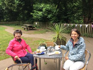
As we approached Saltburn, we spotted a sign for a Victorian tea garden which looked too good to miss. And after all the lovely cafés we’ve passed on our travels so far, we couldn’t resist stopping off for tea and a teacake at the delightful Valley Gardens Tearooms.


After our refreshments we continued alongside the miniature railway track which took us to the seafront. The official Cleveland Way route takes you along a path a little higher than this but both end up at the seafront. The golden sands of Saltburn stretch for miles, north towards Hartlepool and Middlesbrough and South towards Staithes and Whitby.

Saltburn, which was once famous for its smugglers, is well worth a visit. I’d heard a lot about it recently so was keen to look around. After it became a popular Victorian spa resort, a hydraulic lift was built in 1884 so people didn’t have to  clamber up and down the steep slope between the beach and the town. The lift is currently closed due to a major refurbishment so it’s Shanks’s pony until it opens again later in the year.


IMG_5812.JPG

There is also an impressive pier that juts out over the sands…apparently it’s the most northerly surviving British pier and the only remaining pleasure pier on the north east coast.


IMG_5816.JPG

There is certainly lots of refurbishment going on here at the moment and we noticed some very jolly new beach huts being erected on the promenade.


IMG_5821.JPG

Saltburn town centre is certainly a gem. It was voted best place to live last year in the Sunday Times Best Places to Live list. It is populated with stylish cafés, art galleries and independent shops. So after a meander around the town, we thought we had better press on as we had a good few miles ahead of us and time was ticking by.

You leave Saltburn along a path behind the old smugglers’ cottages and The Ship Inn. It’s a pretty steep climb out of the town to get up onto the headland – we are getting used to these uphill hikes by now although I am not sure we are walking them any faster.


IMG_5831.JPG

We were due for our lunch and were lucky enough to find a bench on Hunt Cliff to enjoy our sandwiches along with a blustery cliff top wind.


IMG_5832.JPG

The path further along meets the railway line so for a while you have the cliffs on your left and the train tracks to your right.

IMG_5835.JPG

We were just in time to spot a freight train passing on the route which serves the Boulby Potash Mine.

IMG_5837.JPG

We came across this lovely ironwork sculpture a little further on at Warset Hill. It’s a seven-foot diameter circle with ten sculpted images relating to the history of the area.

IMG_5840.JPG

And we also spotted some wild orchids as we neared the path towards the beach…

IMG_5843.JPG

The path then veers off to the left along a strip of sand dunes behind Cattersty Sands, a lovely sandy beach popular with dog walkers. The beach, incidentally, recently made it into The Telegraph’s Top 40 British Beaches.

We passed the little village of Skinningrove, a traditional fishing port and now a small village community. I wondered what all the many sheds were on a hill behind the village. My mum recognised that they were pigeon lofts, clearly a popular pastime here as we spotted a sculpture commemorating this outside the clubhouse of the pigeon homing society in the village centre.

It was another arduous climb out of Skinningrove, clambering up a flight of never-ending steep, stony steps until we reached the next cliff top. Hummersea Beach is below this grassy cliff which was covered with poppies and wild flowers.

IMG_5851.JPG

From here, we passed through a farm and onto a gorse-covered slope and followed the path along Boulby Cliff, the highest sea cliff in England. There were fantastic views back along the Cleveland Way towards Guisborough Forest and the North York Moors.

We could also see across to the Loftus Alum Quarries. Along the route you can see slag heaps from the steelworks which has solidified and become almost part of the cliffs themselves. We also caught a welcome glimpse of our destination as Staithes came into view a little further along.

IMG_5856.JPG

We passed through Boulby along a narrow road. You get a close up view here of the Boulby Potash Mine, the only potash mine in the country. The route has been moved inland slightly as the original path is in serious danger of sliding into the sea. The path takes you down to the pretty fishing village of Staithes. I can’t imagine many seaside villages having a lovelier approach as this one into Staithes – and this view is one of my all time favourites.

IMG_5859.JPG

We continued down the steep hill towards Cowbar, crossing the bridge into the village and admiring the little cobles, traditional wooden fishing boats, bobbing in the water.

IMG_5864.JPG

We just had time to grab a crab sandwich from the Royal George pub before climbing up another steep hill to the top village of Staithes to catch our bus – or should I say, two buses as we managed to make a connection back to Skelton where we’d parked the car.

All in all, another wonderful walk, this time along the beautiful Yorkshire coastline with its views out to sea on one side, pretty vistas inland as well as magnificent views towards the cliffs further along the route.

The Cleveland Way – Day Five (Kilburn to Skelton Green)

For much of our route along the Cleveland Way, the sharp peak of Roseberry Topping and the statuesque Cook’s Monument have been visible as we have followed ridge lines and escarpments across the North York Moors.


IMG_5580.JPG

The Cleveland Way starts in Helmsley and finishes in Filey and I am doing this 109-mile walk with my mum over the next few months. This fifth section of the walk from Kildale to Skelton enters Captain Cook Country, getting up close to the Cook Monument on Easby Moor and reaching Roseberry Topping on Newton Moor.

We started out at the little village of Kildale and began our climb out of the village, through a conifer plantation, passing Bankside Farm which is in a truly beautiful situation looking back over the valley.


IMG_5745.JPG

Pretty soon after this we took a left turn and headed up a stony flagged path towards Easby Moor. My mum can be seen belting ahead as I held back for a photo opportunity. We are definitely getting used to these craggy, stone steps which have been a feature along the way.


IMG_5746.JPG

As we reached the top of the steps, we were confronted with the 51ft Cook Monument which is far bigger in real life than it has seemed on the horizon up to now. On the side is an inscription dedicated to the famous explorer.


IMG_5747.JPG
IMG_5749.JPG

This famous landmark seemed as good a place as any to stop for lunch. It was an incredibly muggy, airless day which made it hard going on the steep climbs. From the monument you’ve got great views around and can see the next major landmark along this route – Roseberry Topping.


IMG_5751.JPG

From here, it was a short walk along a stone path on Great Ayton Moor and along the side of a forested slope towards Roseberry Topping. You get glimpses of it along the way over the stone wall and fencing.


Climbing Roseberry Topping is an optional part of this route as it was with the Kilburn White Horse, the two spurs of the trail. As I’d climbed Roseberry Topping previously, we decided to continue along the route rather than do the up and down climb, so we turned and followed the path along Newton Moor away from Roseberry Topping.


IMG_5756.JPG

After crossing Newton Moor and Hutton Moor and passing Highcliffe Farm, we were now in the last part of the moorland section of the Cleveland Way. We followed a stone path alongside an old quarry at Highcliffe Nab from where we had great views over the market town of Guisborough below.


IMG_5758.JPG

From here we walked on the escarpment and along a path lined with bright yellow gorse bushes through Guisborough Forest, which was humming with insects and had a lovely aroma of pine which reminded me of being abroad.


After emerging from Guisborough Forest we continued along the route until we entered a more boggy wood following a footpath which leads to the tiny village of Slapewath. You have to cross the busy A171 moor road to Whitby to get there. We stopped at the friendly Fox and Hounds Pub in the village for a wonderfully refreshing ice cream and cup of tea.

We were going to stop here as this brought us to the 10-mile mark but having been revived by the ice cream and tea we decided to plough on for another couple of miles to Skelton. This section officially finishes at Saltburn but we were keen to stop before then so that on the next leg we’d have time to explore Saltburn – with perhaps a little time for a morning coffee.

So, onward. We passed through the little village of Skelton Green, meeting late afternoon dog walkers along the way, before heading through an arch to be greeted with a view over Skelton and the cliffs of Saltburn in the distance.


IMG_5765.JPG

We could also just glimpse the sea from here and it was quite exciting to think that on our next leg of the trail our views would chance as we’d be following the coastal path south.


IMG_5766.JPG

As we entered Skelton, we passed a lovely community orchard called Ringrose Orchard which has been landscaped and beautifully planted by a local group of volunteers.


IMG_5772.JPG
IMG_5768.JPG

In the orchard we came across a bust of explorer Frank Wild, Shackleton’s second-in-command. It was Wild who stayed behind with 21 men on Elephant Island during the Trans-Antarctic Expedition of 1914-16, while Shackleton and his crew of five made their rescue mission to South Georgia aboard a lifeboat. Frank Wild was born in Skelton, the son of a teacher and seamstress, and his statue now proudly surveys the town below.


IMG_5770.JPG

This time we got a taxi back to Kildale to save our other halves from trekking across the moors to collect us. We are now almost at the half way point of the Cleveland Way, having walked up the western side of the North York Moors and across the Cleveland Hills at the top end.

We’ve done a fair bit of hiking across the rugged moorland so from now on it will be mostly cliff top walks, stopping at some of our favourite coastal resorts along the way. So, until then see you next time…

The Cleveland Way ~ Day Four (Clay Bank to Kilburn)

The car park at Clay Bank must be one of the most scenic in the country with dramatic views over the Cleveland Hills and with Roseberry Topping and Captain Cook’s Monument looming in the distance.


IMG_0593.JPG

This is the start of stage four of the Cleveland Way which runs from Clay Bank to Kildale. I am walking this 109-mile national trail in stages over the next few months with my mum.

It’s a good job this car park is so well-appointed as my dad ended up waiting here the previous week for almost two hours while we completed stage three of the Cleveland Way. Equipped with just the newspaper and his Kindle, it was probably the view that kept his spirits up during the wait.

The view from here is so beautiful that it has become a memorial site to loved ones and the viewing platform is adorned with flowers and plaques inscribed with heartfelt tributes. We took a moment to appreciate this beauty spot and the loving words etched on these plaques before embarking on our walk.

From the car park we returned along the road before turning left to follow some steep flagged steps up onto Carr Ridge. It must have taken some effort starting out on such an incline as even my mum, who is normally very talkative, remained silent until we reached the top.


IMG_5664 (1).JPG
IMG_5665.JPG

As the terrain levelled out we turned to look at the view behind us and the route we had taken on the last stage which had taken us up and down five moors.


IMG_5667.JPG

Once we had passed through a grassy meadow we were onto a gritty path taking us across bilberry and heather-clad moorland with only a few sheep and their young offspring for company.


IMG_5670.JPG

We came across this pool of water by the side of the track as we headed towards Urra Moor, the highest moor in the North Yorkshire Moors at 454 metres.


IMG_5674.JPG

From this high up we were rewarded once again with some magnificent views across the the North York Moors. We were lucky that the weather was on our side as you certainly wouldn’t want to be crossing these paths in inclement conditions – one wrong turn and who knows where you would end up.


IMG_5672.JPG

After a while we arrived at Bloworth Crossing, which is an intersection of old railway tracks. If you went straight on from here you would be following the Coast to Coast Walk and end up in Robin Hood’s Bay. Instead we almost doubled back on ourselves following the stony track up a hill.


IMG_5675.JPG

The railway tracks referred to were part of the Rosedale Mineral Railway which ran from 1861 to 1929, transporting iron ore from Rosedale to the furnaces of Durham. Bloworth Crossing was at one time manned by a keeper who lived in a little house alongside the crossing. Although this area feels so remote now, perhaps it was quite a hive of activity back then, although one particular row of cottages was known by locals back then as Siberia owing to its remoteness.

Not far from where we turned, we passed a pair of standing stones. The taller one dates back to 1888 while the shorter one, known as Jenny Bradley’s Cross, is much older.


IMG_5676.JPG

Not long after here we stopped for lunch on a small slope by the side of the track with views over Ingleby Greenhow. From here the track seemed to go on forever. This particularly leg of the Cleveland Way is by far the most remote, crossing the highest part of the moors, including Ingleby Moor and Battersby Moor, eventually reaching a gate at a road.

IMG_5678.JPG

It is fantastic to have access to such trails as the Cleveland Way. However, a nicely painted sign we came across on this route made it clear that not every part of the moors is open access! And not everyone is welcome…


IMG_5684.JPG

As we started our descent along a quiet road next to the slopes of Park Nab, heading towards Kildale, we came across a memorial stone to four young airmen from World War Two whose plane had crashed half a mile from here in January 1941. The four men survived the crash but when they were discovered two days later, they had all perished from exposure which seems so cruel.

Memorials such as this offer glimpses into the often tragic history that this vast moorland has witnessed, little stories that we may never hear about, let alone find ourselves standing in the spot where these events actually took place.


IMG_5683.JPG
IMG_5682.JPG

From here we continued down the road overlooking the green valley below with its patchwork of fields and small clusters of houses and farms dotted across the landscape.


IMG_5693.JPG

We followed the signs to the small village of Kildale, meanwhile circling above us were curlews and lapwings. This is a wonderful place for bird watchers.

Unfortunately the café in Kildale is no longer open so we continued along towards the station. I couldn’t resist a photo of this gorgeous little summer house on our way.


IMG_5697.JPG

St Cuthbert’s Church is situated next to the station. It has a lovely approach along a narrow footpath that crosses the railway, framed by some old yew trees. It is a pretty little 19th Century church with some interesting features. There are four medieval grave slabs in the porch, two of which bear the coat of arms of the Percy family, one of the most powerful noble families in the north of England during the middle ages


IMG_5706.JPG

A friendly chap who was mowing the grass unlocked the church for us to look around. He explained that the modern stained glass window here created in 1992 celebrates aspects of the village community, including a steam train passing through Kildale and the village smithy.


IMG_5704.JPG

I’d also read beforehand that Robert Thompson, the Mouseman had been at work here and left one his telltale carved mice symbols near the altar so I hunted it down and took this photograph.


IMG_5702.JPG

This stage was another memorable route along the Cleveland Way, taking us to the highest point as well as the most remote parts of the North York Moors with glimpses along the way of picturesque valleys below.

Our next leg will take us over the last section of the moors before the Cleveland Way starts its descent along the coast, offering different but equally dramatic views, I am sure. So until then, my walking boots are taking a rest…so see you next time!